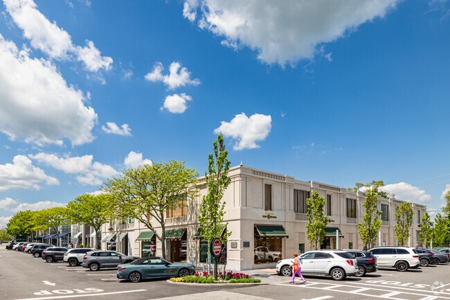
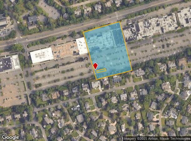
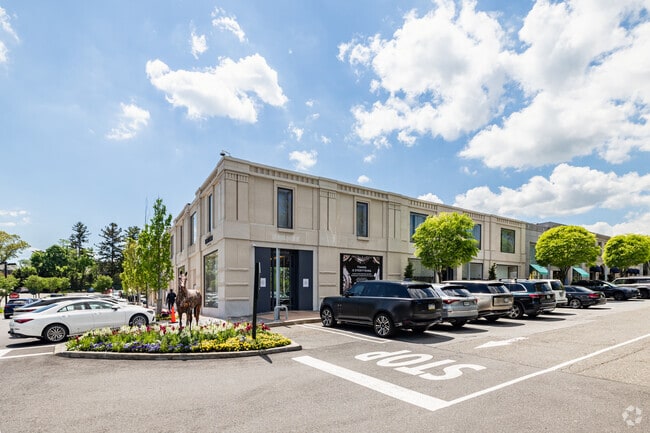
Property Record
1970 Northern Blvd, Manhasset, NY 11030
NEARBY LISTINGS FOR SALE OR LEASE
Property Detail
1970 Northern Blvd
2289-03-219-00-0010-0
TOWN #2 SCH DIST 006
Regionalshoppingcenterormallwithanchorstore
Nassau
X
New York
36059C0116G
10
2025
3.78 AC
2025
Western Nassau
301900
Long Island (New York)
72,576 SF
Nassau County-Suffolk County, NY
DEMOGRAPHICS near 1970 Northern Blvd
1 Mile
3 Mile
5 Mile
2024 Total Population
12,087
106,560
309,681
2029 Population
11,968
105,452
302,470
Pop Growth 2024-2029
(0.98%)
(1.04%)
(2.33%)
Average Age
42
43
43
2024 Total Households
3,883
36,679
107,808
HH Growth 2024-2029
(1.08%)
(1.10%)
(2.51%)
Median Household Inc
$223,740
$159,366
$131,584
Avg Household Size
3.10
2.80
2.80
2024 Avg HH Vehicles
2.00
2.00
2.00
Median Home Value
$1,124,984
$930,342
$826,918
Median Year Built
1952
1954
1954
Nearby Places
- Restaurants
- Banks
- Shops
- Fitness
- Groceries
PUBLIC TRANSPORTATION
COMMUTER RAIL
Manhasset Station (Port Washington Branch - Long Island Rail Road)
DRIVE
WALK
Distance
Manhasset Station (Port Washington Branch - Long Island Rail Road)
4 min
1.8 mi
Plandome Station (Port Washington Branch - Long Island Rail Road)
DRIVE
WALK
Distance
Plandome Station (Port Washington Branch - Long Island Rail Road)
6 min
2.3 mi
AIRPORT
LaGuardia
DRIVE
WALK
Distance
LaGuardia
25 min
14.6 mi
John F Kennedy International
DRIVE
WALK
Distance
John F Kennedy International
28 min
18.2 mi
Westchester County
DRIVE
WALK
Distance
Westchester County
54 min
33.8 mi
Freight Ports
NY - Red Hook Container Terminal
DRIVE
WALK
Distance
NY - Red Hook Container Terminal
36 min
22.7 mi
Nearby Properties
Address
Land Use
TOTAL SIZE
Lot Size
Zoning
Address
Land Use
TOTAL SIZE
Lot Size
Zoning
2.34 AC
Address
Land Use
TOTAL SIZE
Lot Size
Zoning
275,334 SF
9.04 AC
Address
Land Use
TOTAL SIZE
Lot Size
Zoning
680,630 SF
72.68 AC
Address
Land Use
TOTAL SIZE
Lot Size
Zoning
375,331 SF
14.83 AC
Address
Land Use
TOTAL SIZE
Lot Size
Zoning
251,828 SF
31.03 AC
Address
Land Use
TOTAL SIZE
Lot Size
Zoning
152,926 SF
30 AC
Address
Land Use
TOTAL SIZE
Lot Size
Zoning
26,200 SF
186 AC
Address
Land Use
TOTAL SIZE
Lot Size
Zoning
158,725 SF
24.46 AC
Address
Land Use
TOTAL SIZE
Lot Size
Zoning
148,942 SF
34.17 AC
Address
Land Use
TOTAL SIZE
Lot Size
Zoning
401,583 SF
17.93 AC
Address
Land Use
TOTAL SIZE
Lot Size
Zoning
50,252 SF
143.04 AC
Address
Land Use
TOTAL SIZE
Lot Size
Zoning
186,050 SF
8.64 AC
Address
Land Use
TOTAL SIZE
Lot Size
Zoning
84,302 SF
3.49 AC
Address
Land Use
TOTAL SIZE
Lot Size
Zoning
147,148 SF
8.39 AC
Address
Land Use
TOTAL SIZE
Lot Size
Zoning
49,950 SF
51.02 AC
Address
Land Use
TOTAL SIZE
Lot Size
Zoning
171,770 SF
5.95 AC
Address
Land Use
TOTAL SIZE
Lot Size
Zoning
84,966 SF
18.74 AC
Address
Land Use
TOTAL SIZE
Lot Size
Zoning
179,365 SF
6.05 AC
Address
Land Use
TOTAL SIZE
Lot Size
Zoning
45,898 SF
85.13 AC
Address
Land Use
TOTAL SIZE
Lot Size
Zoning
98,439 SF
8.94 AC
Address
Land Use
TOTAL SIZE
Lot Size
Zoning
165,793 SF
18.61 AC
Address
Land Use
TOTAL SIZE
Lot Size
Zoning
23,871 SF
11.07 AC
Address
Land Use
TOTAL SIZE
Lot Size
Zoning
728,546 SF
7.53 AC
Address
Land Use
TOTAL SIZE
Lot Size
Zoning
112,455 SF
69.93 AC
Address
Land Use
TOTAL SIZE
Lot Size
Zoning
60,794 SF
5.71 AC
Address
Land Use
TOTAL SIZE
Lot Size
Zoning
56,663 SF
388.75 AC
Address
Land Use
TOTAL SIZE
Lot Size
Zoning
552,672 SF
8.72 AC
Address
Land Use
TOTAL SIZE
Lot Size
Zoning
109,503 SF
12.88 AC
Address
Land Use
TOTAL SIZE
Lot Size
Zoning
140,916 SF
3.14 AC
Address
Land Use
TOTAL SIZE
Lot Size
Zoning
The World's #1 Commercial Real Estate Marketplace
Connect with us
© 2025 CoStar Group
The information above has been obtained from sources believed reliable. While we do not doubt its accuracy we have not verified it and make no guarantee, warranty or representation about it. It is your responsibility to independently confirm its accuracy and completeness. Any projections, opinions, assumptions, or estimates used are for example only and do not represent the current or future performance of the property. The value of this transaction to you depends on tax and other factors which should be evaluated by your tax, financial, and legal advisors. You and your advisors should conduct a careful, independent investigation of the property to determine to your satisfaction the suitability of the property for your needs.